


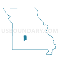
Miller Voting District, Dallas County, Missouri
About
Outline

Summary
| Unique Area Identifier | 607687 |
| Name | Miller Voting District |
| County | Dallas County |
| State | Missouri |
| Area (square miles) | 62.95 |
| Land Area (square miles) | 62.41 |
| Water Area (square miles) | 0.53 |
| % of Land Area | 99.15 |
| % of Water Area | 0.85 |
| Latitude of the Internal Point | 37.82902810 |
| Longtitude of the Internal Point | -92.93121150 |
Maps


Graphs
Select a template below for downloading or customizing gragh for Miller Voting District, Dallas County, Missouri


Neighbors
Neighoring Voting District (by Name) Neighboring Voting District on the Map
- Eldridge Voting District, Laclede County, MO
- Ha Ha Tonka Voting District, Camden County, MO
- Jasper Voting District, Dallas County, MO
- Macks Creek Voting District, Camden County, MO
- Sherman Voting District, Dallas County, MO
- Spring Hollow No. 1 Voting District, Laclede County, MO
Top 10 Neighboring County Subdivision (by Population) Neighboring County Subdivision on the Map
- Russell township, Camden County, MO (4,161)
- Spring Hollow township, Laclede County, MO (4,139)
- Warren township, Camden County, MO (2,922)
- Jasper township, Dallas County, MO (1,019)
- Eldridge township, Laclede County, MO (900)
- Miller township, Dallas County, MO (695)
- Sherman township, Dallas County, MO (536)
Top 10 Neighboring Unified School District (by Population) Neighboring Unified School District on the Map
- Camdenton R-III School District, MO (31,430)
- Lebanon School District, MO (24,821)
- Dallas County R-I School District, MO (12,874)
- Hickory County R-I School District, MO (4,869)
- Macks Creek R-V School District, MO (2,450)
Top 10 Neighboring State Legislative District Lower Chamber (by Population) Neighboring State Legislative District Lower Chamber on the Map
- State House District 155, MO (41,624)
- State House District 146, MO (37,063)
- State House District 119, MO (36,209)
Top 10 Neighboring State Legislative District Upper Chamber (by Population) Neighboring State Legislative District Upper Chamber on the Map
Top 10 Neighboring 111th Congressional District (by Population) Neighboring 111th Congressional District on the Map
Top 10 Neighboring Census Tract (by Population) Neighboring Census Tract on the Map
- Census Tract 9601, Laclede County, MO (8,360)
- Census Tract 9508, Camden County, MO (6,817)
- Census Tract 4801, Dallas County, MO (4,724)